
Soil erosion is a major environmental threat, impacting agricultural productivity and ecosystem health. It’s a complex process influenced by climate, topography, land use, and soil properties.
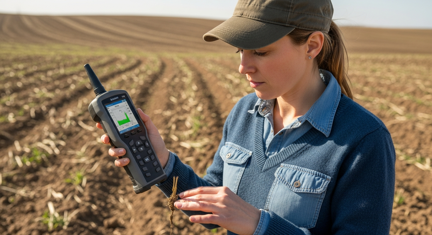
Traditional methods of monitoring erosion can be time-consuming and expensive. Soil spectroscopy offers a rapid and cost-effective alternative for assessing soil erosion and land degradation.
This article explores the application of soil spectroscopy erosion monitoring in precision agriculture. We’ll examine how it can be used to detect erosion patterns, assess land degradation, and develop sustainable land management practices and strategies for soil conservation.
The Problem of Soil Erosion
Soil erosion is the removal of topsoil by natural forces, primarily water and wind. This process leads to loss of fertile land, reduced crop yields, and water pollution.
Erosion also contributes to sedimentation in rivers and lakes, harming aquatic life. The consequences of soil erosion extend beyond agriculture, impacting biodiversity and climate change.
Land degradation, often driven by unsustainable agricultural practices, exacerbates soil erosion. Deforestation, overgrazing, and improper tillage methods disrupt soil structure and increase vulnerability to erosion.
The economic costs of soil erosion are substantial, including decreased agricultural production and increased water treatment expenses. Addressing soil erosion is essential for ensuring food security and environmental sustainability.
The loss of topsoil diminishes the land’s capacity to support plant growth. This directly impacts agricultural yields and the ability to feed a growing global population.
Sedimentation from erosion can clog waterways, hindering navigation and increasing flood risks. This also affects the availability of clean drinking water for communities downstream.
The impact on biodiversity is significant, as erosion destroys habitats and disrupts ecological balance. Many plant and animal species are directly affected by the loss of their natural environment.
Climate change is both a cause and a consequence of soil erosion. Degraded soils release carbon into the atmosphere, contributing to greenhouse gas emissions and further exacerbating climate change.
Unsustainable agricultural practices, such as monoculture farming, deplete soil nutrients and weaken its structure. This makes the soil more susceptible to the erosive forces of wind and water.
Overgrazing removes vegetation cover, leaving the soil exposed and vulnerable. The hooves of livestock compact the soil, reducing its ability to absorb water and increasing runoff.
Deforestation for agriculture or logging removes the protective canopy of trees. The exposed soil is then directly impacted by rainfall and wind, leading to accelerated erosion rates.
Improper tillage techniques, such as plowing up and down slopes, create channels for water to flow and erode the soil. This can lead to the formation of gullies and significant soil loss.
The financial burden of soil erosion extends to both farmers and governments. Farmers face reduced yields and increased input costs, while governments must invest in water treatment and infrastructure repair.
Protecting soil resources is not just an environmental imperative, but also an economic necessity. Sustainable land management practices are crucial for ensuring food security and long-term economic stability.
Traditional Methods for Monitoring Erosion
Traditional methods for monitoring soil erosion often involve field observations and measurements. These methods include visual assessment, erosion pins, and sediment traps.
Visual assessment relies on expert judgment to identify areas of active erosion. While simple and inexpensive, this method is subjective and prone to errors.
Erosion pins are metal rods inserted into the ground to measure changes in soil surface elevation over time. This provides quantitative data on soil loss or deposition, but it’s labor-intensive and only captures localized erosion.
Sediment traps collect eroded soil particles transported by water runoff. Analyzing the collected sediment provides information on the amount and source of soil loss, but requires significant effort and resources.
Rainfall simulators are used to mimic natural rainfall events and measure the resulting runoff and soil loss. This allows researchers to study the effects of different land management practices on erosion rates.
Stream gauging stations measure the flow rate and sediment load of rivers and streams. This provides information on the overall erosion rates within a watershed.
Aerial photography and satellite imagery can be used to identify areas of erosion and track changes in land cover over time. This provides a broad overview of erosion patterns, but requires specialized equipment and expertise.
Field surveys involve detailed mapping of soil types, slope angles, and land cover. This information is used to assess the potential for erosion in different areas.
Visual assessment is often the first step in erosion monitoring. Experts look for signs of rills, gullies, and sheet erosion, as well as changes in vegetation cover and soil color.
While visual assessment can be useful for identifying obvious areas of erosion, it’s limited by its subjectivity and inability to detect subtle changes. The accuracy of visual assessment depends heavily on the experience and training of the observer.
Erosion pins provide a more quantitative measure of soil loss or deposition. However, they only measure erosion at a single point, and many pins are needed to accurately represent erosion rates across a field.
Sediment traps can provide valuable information on the amount and source of soil loss. However, they are time-consuming to install and maintain, and the collected sediment must be carefully analyzed in a laboratory.
Rainfall simulators are useful for studying the effects of different land management practices on erosion rates. However, they are expensive and require specialized equipment and expertise.
Stream gauging stations provide valuable data on overall erosion rates within a watershed. However, they do not provide information on the specific sources of erosion.
Aerial photography and satellite imagery can provide a broad overview of erosion patterns. However, the resolution of the imagery may not be high enough to detect subtle changes in soil surface elevation.
Field surveys are essential for understanding the factors contributing to erosion. However, they are time-consuming and require specialized expertise in soil science and land management.
Using Spectroscopy to Detect Erosion Patterns
Soil spectroscopy offers a rapid and non-destructive method for characterizing soil properties. It involves measuring the interaction of electromagnetic radiation with soil samples.
The spectral reflectance of soil is influenced by its mineral composition, organic matter content, and moisture levels. Soil spectroscopy erosion monitoring can detect subtle changes in these properties caused by erosion.
| Erosion Indicator | Spectroscopic Feature | Interpretation |
|---|---|---|
| Organic Matter Loss | Decreased reflectance in visible and near-infrared regions | Reduced soil fertility and water-holding capacity |
| Clay Mineral Depletion | Changes in reflectance in the shortwave infrared region | Increased soil erodibility and decreased nutrient retention |
| Iron Oxide Enrichment | Increased reflectance in the red region | Indicates removal of topsoil and exposure of subsoil |
| Texture Changes | Variations in spectral shape and intensity | Reflects the selective removal of fine particles |
Spectroscopy analyzes the wavelengths of light reflected from a soil sample. Each component of the soil absorbs and reflects light differently, creating a unique spectral signature.
By comparing the spectral signatures of eroded and non-eroded soils, we can identify the key spectral features associated with erosion. These features can then be used to map erosion patterns across a landscape.
The visible and near-infrared (VNIR) region of the electromagnetic spectrum is particularly sensitive to soil organic matter. Erosion typically leads to a decrease in soil organic matter, which results in a decrease in reflectance in the VNIR region.
The shortwave infrared (SWIR) region is sensitive to soil mineral composition. Changes in clay mineral content due to erosion can be detected by analyzing reflectance in the SWIR region.
Iron oxides, which are often enriched in subsoil, have a characteristic spectral signature in the red region. Increased reflectance in the red region can indicate the removal of topsoil and exposure of subsoil due to erosion.
Soil texture, which refers to the proportion of sand, silt, and clay, also influences spectral reflectance. Erosion often leads to the selective removal of fine particles, which can be detected by analyzing variations in spectral shape and intensity.
Spectral libraries, which contain the spectral signatures of different soil types and land cover classes, are essential for accurate erosion assessment. These libraries can be used to compare the spectral signatures of unknown soil samples and identify areas of erosion.
Chemometric techniques, such as partial least squares regression (PLSR), can be used to develop predictive models for erosion assessment. These models relate spectral reflectance to soil properties, such as organic matter content and clay mineral content.
Remote sensing data, such as satellite imagery and aerial photography, can be combined with soil spectroscopy to map erosion patterns over large areas. This allows for a more comprehensive assessment of erosion risk.
The accuracy of soil spectroscopy for erosion assessment depends on several factors, including the quality of the spectral data, the representativeness of the soil samples, and the accuracy of the spectral models. Careful attention to these factors is essential for obtaining reliable results.
Soil moisture content can significantly influence spectral reflectance. It’s important to account for soil moisture variations when analyzing spectral data for erosion assessment.
Surface roughness can also affect spectral reflectance. Rough surfaces tend to scatter light more than smooth surfaces, which can influence the spectral signature of the soil.
Vegetation cover can mask the spectral signature of the soil. It’s important to remove or account for vegetation effects when analyzing spectral data for erosion assessment.
Benefits of Rapid Erosion Assessment
Rapid erosion assessment using soil spectroscopy provides several advantages over traditional methods. It allows for the analysis of large areas in a relatively short amount of time.
Spectroscopic measurements can be collected remotely using sensors mounted on drones or satellites. This enables the creation of high-resolution erosion maps, showing areas of high erosion risk.
The non-destructive nature of spectroscopy means that soil samples can be analyzed repeatedly without alteration. This is particularly useful for monitoring the effectiveness of soil conservation practices over time.
Soil spectroscopy erosion monitoring can be integrated with other data sources, such as climate data and topographic maps. This allows for a more comprehensive understanding of the factors driving soil erosion.
The speed of spectroscopic analysis allows for timely intervention and implementation of conservation measures. Early detection of erosion problems can prevent further degradation and minimize economic losses.
Remote sensing capabilities enable access to remote and difficult-to-reach areas. This is particularly important for monitoring erosion in mountainous regions or areas with limited infrastructure.
The ability to repeatedly analyze soil samples without destruction allows for long-term monitoring of soil health. This provides valuable information for assessing the sustainability of agricultural practices.
Integrating spectroscopic data with climate and topographic information allows for the development of predictive models. These models can be used to identify areas that are most vulnerable to erosion under different climate scenarios.
The cost-effectiveness of soil spectroscopy makes it an attractive option for farmers and land managers. The reduced labor and time requirements can lead to significant savings.
The objective nature of spectroscopic measurements reduces the subjectivity associated with traditional methods. This leads to more consistent and reliable erosion assessments.
High-resolution erosion maps can be used to target conservation efforts to the areas where they are most needed. This ensures that resources are used efficiently and effectively.
The ability to monitor the effectiveness of conservation practices over time allows for adaptive management. Practices can be adjusted based on their performance to optimize soil conservation outcomes.
Soil spectroscopy can be used to assess the impact of different land use practices on soil erosion. This information can be used to promote more sustainable land management.
The data obtained from soil spectroscopy can be used to inform policy decisions related to soil conservation. This helps to ensure that policies are based on sound scientific evidence.
The rapid assessment capabilities of soil spectroscopy can be particularly valuable in emergency situations, such as after a major storm or wildfire. This allows for quick assessment of erosion damage and implementation of emergency stabilization measures.
By providing a more comprehensive understanding of soil erosion processes, soil spectroscopy can contribute to the development of more effective soil conservation strategies. This will help to protect our valuable soil resources for future generations.
Integrating Erosion Data into Conservation Plans
Erosion data obtained from soil spectroscopy can be used to develop targeted soil conservation plans. These plans can be tailored to specific areas based on their erosion risk and soil properties.
Conservation practices such as contour plowing, terracing, and cover cropping can be implemented to reduce soil erosion. These practices help to improve soil structure, increase water infiltration, and reduce runoff.
Spectroscopic data can also be used to monitor the effectiveness of conservation practices. Changes in soil properties can be tracked over time to assess whether the practices are achieving their intended goals.
By integrating erosion data into conservation plans, farmers and land managers can make informed decisions about land use. This leads to more sustainable agricultural practices and better protection of soil resources.
Detailed erosion maps derived from spectroscopy can pinpoint areas requiring immediate attention. This allows for efficient allocation of resources and prioritization of conservation efforts.
Soil-specific conservation strategies can be implemented based on the unique properties identified through spectroscopy. This ensures that the most appropriate practices are used for each area.
Contour plowing follows the natural contours of the land, reducing the speed of water flow and minimizing erosion. This practice is particularly effective on sloping land.
Terracing creates a series of level platforms on a slope, reducing the slope length and preventing runoff from accumulating. Terraces are often used in areas with steep slopes and high erosion risk.
Cover cropping involves planting a temporary crop to protect the soil surface during fallow periods. Cover crops help to improve soil structure, reduce erosion, and suppress weeds.
No-till farming minimizes soil disturbance by eliminating plowing and other tillage operations. This helps to improve soil structure, reduce erosion, and conserve soil moisture.
Windbreaks, which are rows of trees or shrubs planted along the edges of fields, can reduce wind erosion. Windbreaks also provide habitat for wildlife and can improve air quality.
Vegetative buffer strips, which are strips of vegetation planted along waterways, can filter runoff and reduce sedimentation. Buffer strips also provide habitat for wildlife and can improve water quality.
Spectroscopic data can be used to track changes in soil organic matter content over time. This is an important indicator of soil health and the effectiveness of conservation practices.
Changes in soil texture, as measured by spectroscopy, can indicate the effectiveness of practices aimed at reducing soil erosion. An increase in clay content may indicate reduced erosion.
Erosion models can be calibrated and validated using spectroscopic data. This allows for more accurate predictions of erosion rates under different land management scenarios.
By making informed decisions about land use, farmers and land managers can improve their long-term profitability. Sustainable agricultural practices can lead to higher yields and reduced input costs.
Practical Steps for Soil Conservation
Effective soil conservation requires a multifaceted approach that addresses the root causes of erosion. Implementing practical steps can significantly reduce soil loss and enhance land productivity.
These steps range from adopting appropriate tillage methods to planting vegetation that protects the soil surface. Each measure contributes to a more resilient and sustainable agricultural system.
- Implement no-till or reduced tillage practices
- Plant cover crops during fallow periods
- Use contour plowing on sloping land
- Construct terraces to reduce slope length
- Maintain adequate vegetation cover to protect the soil
No-till farming minimizes soil disturbance, preserving soil structure and reducing erosion. This also helps to conserve soil moisture and improve soil health.
Reduced tillage practices, such as chisel plowing, can also help to reduce erosion. These practices leave more crop residue on the soil surface, protecting it from wind and water erosion.
Cover crops provide a protective layer on the soil surface, preventing erosion during fallow periods. They also improve soil structure, add organic matter, and suppress weeds.
Contour plowing slows down water flow, reducing its erosive power. This is particularly effective on sloping land where water runoff is a major concern.
Terraces break up long slopes into shorter, level sections, preventing water from accumulating and causing erosion. This is a common practice in mountainous regions and areas with steep slopes.
Maintaining adequate vegetation cover is crucial for protecting the soil from erosion. Vegetation acts as a barrier, intercepting rainfall and reducing the impact of wind.
Crop rotation can improve soil health and reduce erosion by varying the types of crops grown in a field. Different crops have different root systems and nutrient requirements, which can help to improve soil structure and reduce erosion.
Adding organic matter to the soil can improve its structure and water-holding capacity, reducing erosion. Organic matter can be added in the form of compost, manure, or cover crops.
Proper irrigation management can prevent waterlogging and reduce erosion. Over-irrigation can lead to runoff and erosion, while under-irrigation can stress plants and make them more susceptible to erosion.
Controlling grazing intensity can prevent overgrazing and reduce erosion. Overgrazing removes vegetation cover, leaving the soil exposed and vulnerable to erosion.
Implementing integrated pest management (IPM) practices can reduce the need for pesticides, which can harm soil organisms and reduce soil health. IPM practices include crop rotation, biological control, and the use of resistant varieties.
Protecting riparian areas, which are the areas along rivers and streams, can help to reduce erosion and improve water quality. Riparian areas provide habitat for wildlife and can filter runoff from agricultural fields.
Implementing soil conservation practices requires a long-term commitment and careful planning. It’s important to assess the specific erosion risks in each area and select the appropriate conservation practices.
Education and outreach are essential for promoting soil conservation. Farmers and land managers need to be informed about the benefits of soil conservation and the available conservation practices.
Government policies can play a crucial role in promoting soil conservation. Policies can provide incentives for farmers to adopt conservation practices and can regulate land use to prevent erosion.
Challenges in Spectroscopic Erosion Analysis
While soil spectroscopy offers numerous benefits, it also presents certain challenges. Interpreting spectral data requires expertise and careful calibration.
The spectral reflectance of soil can be influenced by factors other than erosion, such as moisture content and surface roughness. These factors need to be accounted for in the analysis to avoid misinterpretations.
Developing accurate spectral models for erosion assessment requires a large and representative dataset. This can be challenging to obtain, especially in areas with diverse soil types and land uses.
The cost of spectroscopic equipment and software can be a barrier for some users. However, the long-term benefits of rapid erosion assessment often outweigh the initial investment.
The need for specialized knowledge in spectroscopy and data analysis can be a significant hurdle. Training and education are crucial for successful implementation.
Variations in soil moisture can significantly affect spectral readings, requiring careful calibration and correction. This is particularly important in areas with fluctuating rainfall patterns.
Surface roughness can also influence spectral reflectance, making it difficult to isolate the effects of erosion. Accounting for surface roughness requires additional data and analysis.
The presence of vegetation cover can interfere with soil spectral measurements. Removing or accounting for vegetation effects is essential for accurate erosion assessment.
Developing robust spectral models requires a diverse and representative dataset that captures the range of soil types and erosion conditions in a study area. This can be a time-consuming and expensive process.
The accuracy of spectral models depends on the quality of the reference data used for calibration. Accurate and reliable reference data are essential for developing robust models.
The transferability of spectral models between different regions or time periods can be limited. Models developed in one area may not be accurate in another area due to differences in soil properties and climate.
The cost of spectroscopic equipment and software can be a significant barrier for small farmers and land managers. Affordable and accessible technologies are needed to promote wider adoption.
The complexity of spectral data analysis can be daunting for users without specialized training. User-friendly software and tools are needed to make spectroscopic analysis more accessible.
The integration of spectroscopic data with other data sources, such as climate and topographic data, can be challenging. Standardized data formats and protocols are needed to facilitate data integration.
The validation of spectroscopic erosion assessments can be difficult and time-consuming. Traditional erosion monitoring methods are often needed to validate the results of spectroscopic analysis.
Case Studies: Spectroscopy in Action
Several studies have demonstrated the effectiveness of soil spectroscopy in erosion monitoring. These case studies highlight the practical applications of this technology in different agricultural settings.
In one study, researchers used soil spectroscopy to assess erosion rates in a vineyard in California. The results showed a strong correlation between spectral reflectance and soil organic matter content, a key indicator of erosion.
Another study used spectroscopy to map soil erosion in a pasture in Australia. The maps revealed areas of severe erosion that were not apparent from visual inspection.
These studies demonstrate the potential of soil spectroscopy to provide valuable information for soil conservation planning. The increased adoption of this technology will help to improve land management practices and protect soil resources.
A study in the Loess Plateau of China utilized spectroscopy to assess the effectiveness of different soil conservation measures. The results showed that terracing and afforestation significantly reduced soil erosion rates.
Researchers in Spain employed spectroscopy to monitor soil degradation in olive groves. The study found that spectral indices could accurately predict soil organic carbon and other indicators of soil health.
In the Midwestern United States, spectroscopy was used to assess the impact of different tillage practices on soil erosion. The results indicated that no-till farming significantly reduced soil loss compared to conventional tillage.
A case study in Kenya demonstrated the use of spectroscopy for mapping soil erosion in smallholder farms. The maps were used to identify areas requiring targeted conservation interventions.
Researchers in Brazil used spectroscopy to assess the impact of deforestation on soil erosion in the Amazon rainforest. The study found that deforestation significantly increased soil erosion rates.
A study in Italy utilized spectroscopy to monitor soil erosion in vineyards affected by wildfires. The results showed that spectral indices could accurately predict soil loss and identify areas requiring rehabilitation.
In South Africa, spectroscopy was used to assess the impact of overgrazing on soil erosion in rangelands. The study found that overgrazing significantly increased soil erosion rates and reduced vegetation cover.
A case study in Canada demonstrated the use of spectroscopy for mapping soil erosion in agricultural fields affected by wind erosion. The maps were used to identify areas requiring windbreaks and other conservation measures.
These case studies highlight the versatility of soil spectroscopy for monitoring soil erosion in a wide range of environments and agricultural settings. The results demonstrate the potential of this technology to inform soil conservation planning and improve land management practices.
The use of spectroscopy in these studies has led to more efficient and effective soil conservation efforts. By providing accurate and timely information on soil erosion, spectroscopy can help to protect our valuable soil resources for future generations.
The successful application of spectroscopy in these case studies underscores the importance of investing in research and development to further improve this technology. Continued innovation in soil spectroscopy will lead to even more effective soil conservation strategies.
The lessons learned from these case studies can be applied to other regions and agricultural systems around the world. By sharing knowledge and best practices, we can promote the wider adoption of soil spectroscopy for erosion monitoring.
Future Trends in Soil Spectroscopy for Erosion Monitoring
The field of soil spectroscopy is constantly evolving, with new technologies and applications emerging. Future trends include the development of more sophisticated spectral models.
Advances in sensor technology are leading to the development of smaller and more affordable spectrometers. This will make soil spectroscopy more accessible to farmers and land managers.
The integration of artificial intelligence and machine learning is enhancing the ability to analyze spectral data. This allows for more accurate and efficient erosion assessment.
As the demand for sustainable agriculture grows, soil spectroscopy will play an increasingly important role in erosion monitoring. This technology will help to ensure the long-term health and productivity of our soils.
The development of hyperspectral sensors will provide more detailed spectral information. This will allow for more accurate identification of soil properties and erosion indicators.
The use of unmanned aerial vehicles (UAVs) or drones for spectral data collection is becoming increasingly common. Drones offer a cost-effective way to collect high-resolution spectral data over large areas.
Machine learning algorithms can be used to develop more accurate and robust spectral models. These algorithms can learn complex relationships between spectral reflectance and soil properties.
The integration of soil spectroscopy with other remote sensing techniques, such as LiDAR and radar, will provide a more comprehensive assessment of soil erosion. This will allow for the development of more effective conservation strategies.
The development of portable and handheld spectrometers will make it easier for farmers and land managers to collect spectral data in the field. This will allow for more timely and informed decision-making.
The use of cloud computing and data analytics will facilitate the processing and analysis of large spectral datasets. This will make it easier to identify erosion patterns and trends.
The development of spectral libraries for different soil types and land cover classes will improve the accuracy of erosion assessments. These libraries will provide a valuable resource for researchers and practitioners.
The integration of soil spectroscopy with precision agriculture technologies will allow for more targeted and efficient soil conservation efforts. This will help to optimize crop yields and minimize environmental impacts.
The development of user-friendly software and tools will make soil spectroscopy more accessible to a wider audience. This will promote the wider adoption of this technology for erosion monitoring.
The increasing awareness of the importance of soil health will drive the demand for soil spectroscopy. This technology will play a key role in promoting sustainable land management practices.
The development of international standards for soil spectroscopy will improve the comparability of data and facilitate the exchange of knowledge. This will promote the global adoption of this technology.
Conclusion
Soil spectroscopy offers a powerful tool for monitoring soil erosion and land degradation. Its rapid, non-destructive nature makes it well-suited for precision agriculture.
By integrating erosion data into conservation plans, we can promote sustainable land management and protect our valuable soil resources. Soil spectroscopy erosion monitoring contributes to a more sustainable future.